


Share
- Exploration
Pluto reveals even more
Published on 11 September 2015
After its flyby of the dwarf planet on 14 July, the New Horizons spacecraft has sent its first items of data. It will take more than a year to receive all of it! New images received in early September confirm Pluto's complex geology.

“The surface of Pluto is every bit as complex as that of Mars” said Jeff Moore, one of the scientists working on the New Horizons mission. Not bad for a world that was thought to be frozen and dead… But that was before the historic flyby of the distant dwarf planet (once the 9th and most distant fully-fledged planet in the solar system) by NASA’s New Horizons on 14 July.
During the flyby, the spacecraft dedicated itself fully to collecting images and data and only a few shots were sent the in the days immediately afterwards. These early images already revealed a complex geology with some terrains only 100 million years old and thus young, in geological terms. In particular, these comprise a vast plain of frozen nitrogen (with waves in places that resemble glaciers) and mountains of water ice (water ice as hard as rock at the -220 ∞C temperatures that prevail on the planet). In places, these mountains peak at heights of 3.5 km from the surrounding surface.
This recent geological activity raises the issue of its “driving force”. In theory, a heat source is needed as a core which would still be hot, but a world as small as Pluto (2370 km in diameter, which is smaller than Earth’s Moon!) would have cooled a long time ago. In short, the dwarf planet is surprising. Scientific boss of the New Horizons mission, Alan Stern stated that “Pluto is showing us a diversity of landforms and complexity of processes that rival anything weíve seen in the solar system”.
The new images are below.
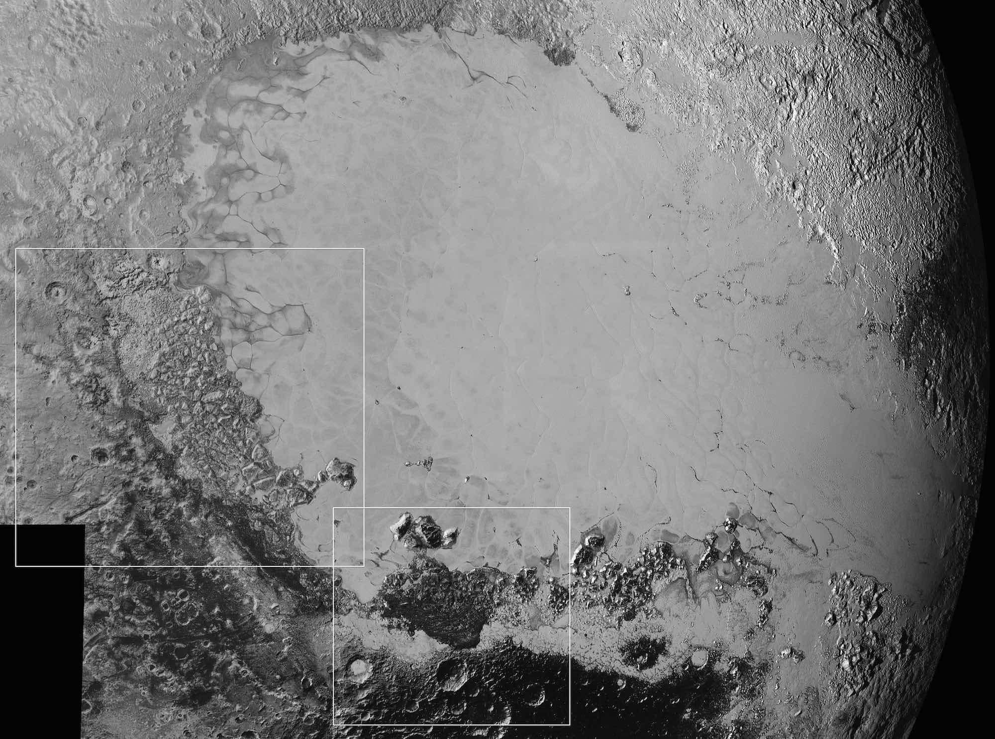
The icy plain of Sputnik Planum in Pluto’s so-called heart region (or Tombaugh Region) dominates this set of images that covers an area 1,600 km wide. Sputnik Planum is surrounded by older terrains (particularly below and to the left) where we see impact craters. Indeed, a surface devoid of craters reveals geological processes that have recently erased traces of impact. The white rectangles show the locations of two areas presented in closeup below. Image credit: NASA/Johns Hopkins University Applied Physics Laboratory/Southwest Research Institute
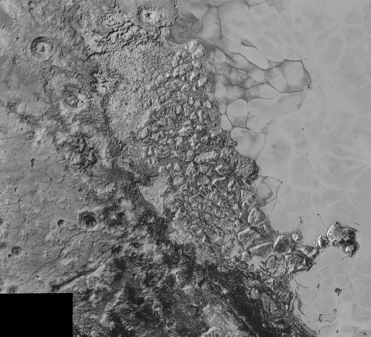
This first “closeup”, 470 km wide, details a transition area between the icy plain of Sputnik Planum to the right and the older, heavily cratered terrains to the left. Image credit: NASA/Johns Hopkins University Applied Physics Laboratory/Southwest Research Institute
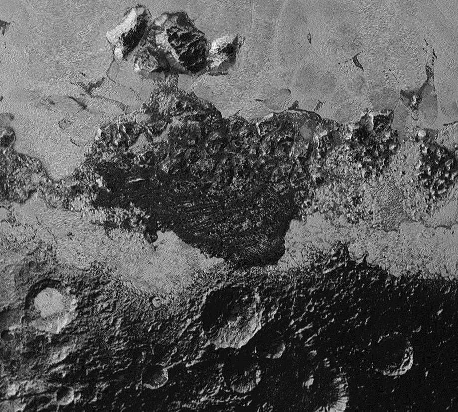
This second “closeup”, 350 km wide, shows a small part of Sputnik Planum at the top and dark, very uneven, older and heavily cratered terrains. In places, scientists observe dark “ripples” that could be dunes. The word “could” is key here, because it is difficult to explain the formation of dunes with wind in Pluto’s very low density atmosphere (10,000 times less than Earth’s). Image credit: NASA/Johns Hopkins University Applied Physics Laboratory/Southwest Research Institute

On the left, this image shows part of the mountains of water ice 3.5 km high. On the right, the same image has been greatly brightened: the faint light reflected by Pluto’s atmosphere illuminates the terrain which is still in Pluto’s night. Image credit: NASA/Johns Hopkins University Applied Physics Laboratory/Southwest Research Institute
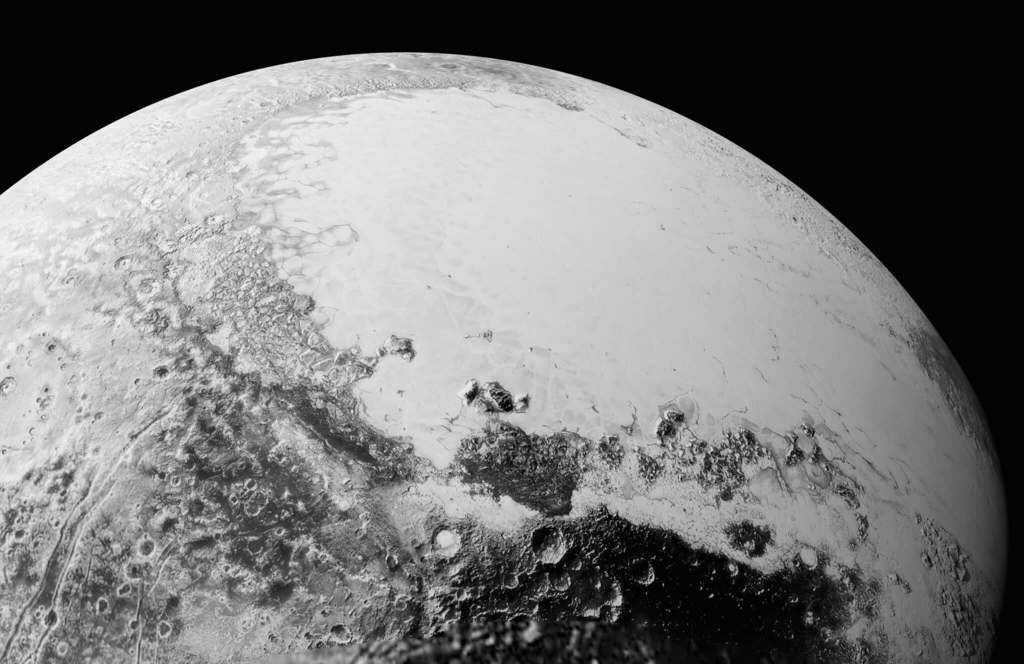
This mosaic of photos brings together the images presented above and taken by New Horizons at a distance of 50,000 to 80,000 km. The images have been assembled here in order to simulate what would be seen from an altitude of 1,800 km above Pluto’s equator. Image credit: NASA/Johns Hopkins University Applied Physics Laboratory/Southwest Research Institute

Pluto backlit after the flyby and at a distance of 770,000 km. The right view is the same as the left, but processed in order to reveal more detail. Scientists observe that there are several layers within the dwarf planet’s atmosphere. An atmosphere that extends upwards much more than was expected. Image credit: NASA/Johns Hopkins University Applied Physics Laboratory/Southwest Research Institute
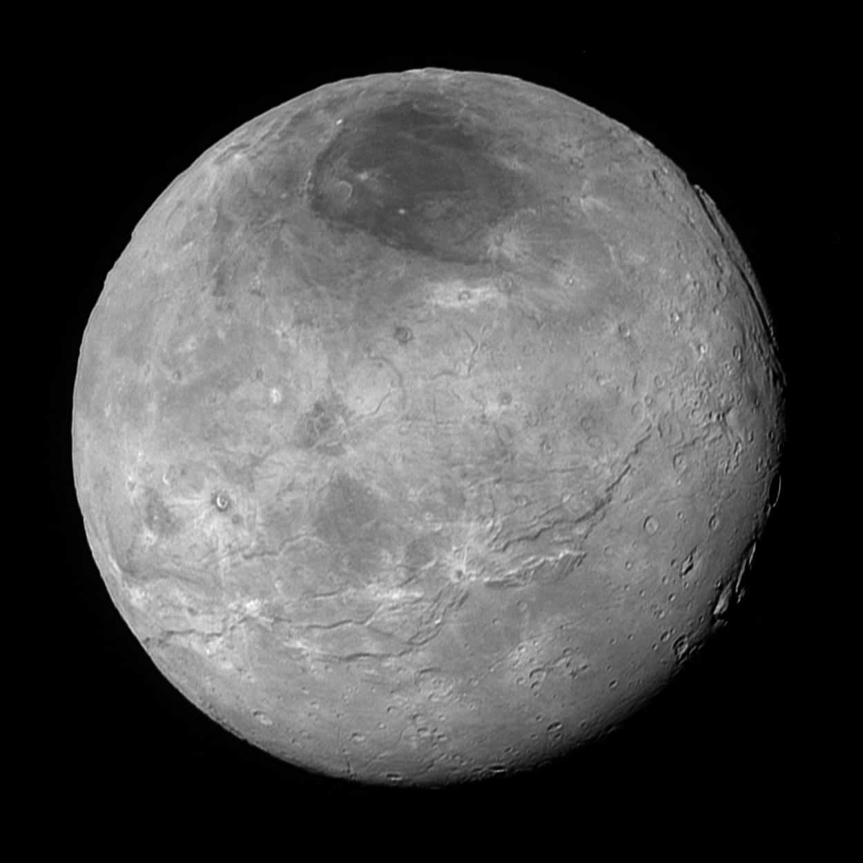
Charon, Pluto’s largest moon (1,170 km in diameter) shown here in more detail than in a previous image that was transmitted with a higher data compression. Once again complex geology is at work and the terrains seem to have been recently modified (geologically-speaking). Image credit: NASA/Johns Hopkins University Applied Physics Laboratory/Southwest Research Institute
New Horizons is travelling at over 5 billion kilometres from Earth. Due to this great distance, the data transmission takes time because the signal received is very weak. A single compressed image takes 1 hour! It will take more than a year for all the data collected during the flyby to reach our planet. Other images of Pluto’s surface are expected, but also of Charon and other small moons several kilometres across (4 in addition to Charon).